
Once we entered Wyoming two main attractions pulled us in their direction; Grand Teton National Park and Yellowstone National Park. Since we were traveling in a Northward direction our first stop would be Grand Teton.

We first stopped in at the Jenny Lake Visitor Center to check out the conditions and trail/area closures due to smoke or bear activity. Besides the smoke it was an overcast and drizzly day and as we pulled into the parking area we were greeted by a smokey, hazy, damp rainbow.

The path down to several of the Jenny Lake observation areas were paved and foot traffic was sparse due to the weather we were guessing. This made it quick and easy for us to get some shots of Willow with Jenny Lake itself and the surrounding mountains just about when the morning clouds and haze were beginning to break.


We drove a large circle in the area over two days using Jenny Lake Road and Teton Park Roads (one day clockwise, the next counter-clockwise). We made a point to pull in and stop at each and every turnout to see what vistas were on offer. Depending on traffic and crowds we sometimes chose to bypass a particular vista spot and leave it hoping to return when crowds had subsided. Due to the ever-changing weather and smoke conditions some vistas were better than others.
 The area between the two roads is terraced by the actions of the Snake River over millennia. Millions of years ago when glaciers were much larger and more numerous those seasonal melts would fill this valley and work their erosive magic. Those floods eventually removed softer soils and left behind harder stones and gravel which resulted in a hard, rocky plain. As these glaciers all shrunk and some disappeared those seasonal melts resulted in less water flowing through the valley and so each subsequent erosive era was smaller and narrower than its predecessor. Eventually the river consolidated itself into a narrower channel and cut down through the rocky strata creating the path we see and enjoy today.


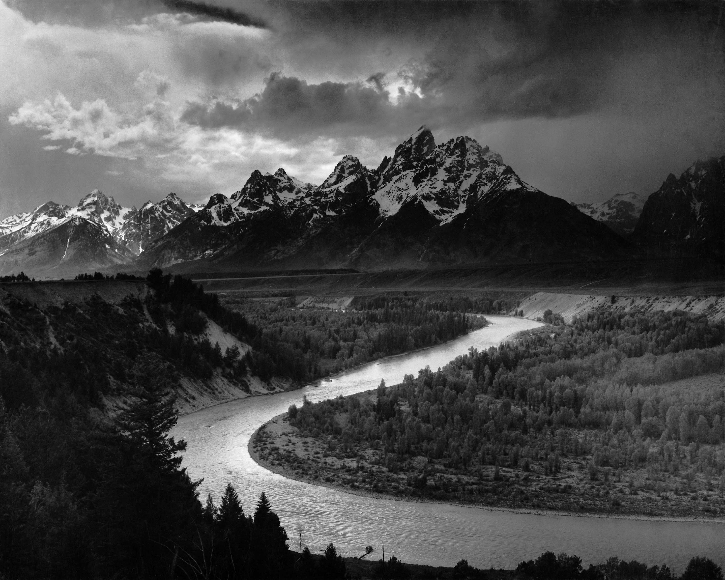
Besides the erosive forces of water over millions of years the other massive geological force that has shaped (and is continuing to shape) this valley is Plate Tectonics. The easiest way to understand this area’s powerful geologic forces is to imagine that the Teton Mountain Range and the valley below are like two sides of a massive, 40-mile-long hinge called the Teton fault. The Earth’s crust breaks into two blocks along this fault. The Eastern side hinges down and forms the valley while the Western half tilts up and has become the Teton Range. An interesting detail of these competing forces is that the Teton Range is composed of some of the oldest rocks on Earth but is one of the youngest mountain ranges in North America. The tectonic forces that have pushed the range up to its present height began only nine million years ago where, as a competing example, the Rocky Mountain Range began their growth about 61 million years before that.
When we were not actively exploring in the National park we spent our down time at a very nice camping spot in between the two National Parks about 10 miles west of the Headwaters Lodge on Highway 89/191.
 Depending on what map you are looking at this road is either called Ashton-Flagg Ranch Road, Grassy Lake Road or (on the section between Grassy Lake itself and the Headwaters Lodge) the John D. Rockefeller Jr. Memorial Parkway.

On our way down that road we drove past a strung out collection of nice, developed campsites and more than half were empty.


We would have happily chosen to stay at any number of those spots but had obviously driven past the zone where AT&T gave a crap about offering cellular coverage and so we had no idea whether reservations or fees were needed to claim one of those spots and so continued down the road in search of just the right spot. When we came back out into AT&T range a few days later we found out that those were the 20 dispersed campsites which are free of charge and available first-come, first-served beginning June 1 and open until the road is closed in winter.
As we came to the Grassy Lake Reservoir we drove past a couple of spots that looked promising but a few were occupied and we still had a several more hours of daylight available to find the perfect spot. Once we got to the far end of the lake we found a little road off to the left pointing to Tillery Lake and took it just because.
 We quickly came to a dead-end with the perfect camping spot except that it had already been claimed by what looked to be one of those folks who are living the house-less traveler lifestyle full-time and stay as long as possible once they find a suitable site. There were a couple of obvious spots we could have claimed right in the general area as well but we didn’t want to intrude. Instead we took the next few minutes to walk around and explore the cool, old earthen-fill dam which makes Tillery Lake possible.
 Unlike most dams we have seen or explored this one looked like it was designed to have its streamside face used as somewhat of a spillway and so it had been protected with round, natural logs held in place and reinforced with iron straps.

The top surface was actual lumber and extremely slippery with a light coating of moss and algae. There was an obvious road on the other side of the dam and no gate, chain or sign keeping us from attempting that crossing in the Tacoma but I was having enough trouble keeping my balance and even Willow with her 4-paw-drive was a bit unsteady on her feet. We ultimately decided to not take the chance of dumping our truck in the lake or down the face of the dam while attempting that crossing…which would have truly sucked. I bet there would have been at least a few empty campsites and greatly reduced traffic over there. Maybe there is an access road coming in to that side of the dam further down Grassy Lake Road. We’ll look for that next time.

By now it was early afternoon on a Friday and, as we were planning on staying away from the weekend National Park crowds, we really wanted to find a site and get situated before any weekend campers arrived on the scene and limited our choices. We decided that we had passed many “good enough” sites on our way in and so just headed back out along Grassy Lake Road. This time we made a stop at the Grassy Lake Dam to take a look… just because. On one hand dams are an environmental disaster with the damage they do to species and the ecosystem but on the other hand they are amazing pieces of structural engineering. I am conflicted that way.
 As we were passing several sites too close to the road or too close to the lake with zero tree coverage we remembered that there was a site, the first one we had taken a look at on the way in and the first along Grassy Lake itself and aimed in that direction. When we arrived it was still unoccupied and so we claimed it and set up what would be our camp for the next couple of days. Once we were comfortably situated I celebrated with a well-named and exceedingly local brew. We’re all about the locavore scene.

Willow celebrated with a stick chew, that is until one of the local squirrel denizens chastised Willow and made his presence known.
Situated at the very Eastern tip of the lake the site was also within a 2 minute walk to the apparent border of the Targhee National Forest.
 For the remainder of the weekend we hung out quietly at our camp spot, took numerous day hikes and caught up on our old-school, offline reading because 1) we like it and 2) we were back in an all-too-common AT$T suck zone and had zero cell signal.
The lake itself was on the low side and so was ringed with sections of muddy or rocky shoreline which hindered my movement a bit but didn’t seem to put too much of a cramp in Willow’s style.

A resident pair of geese seemed to be making their home at our end of the lake and made several daily forays out to do whatever it is that geese do during the day. We could easily keep an eye on their comings and goings because they were quite the vocal pair and kept up an enthusiastic call and response in order to know each others positions.
While we had been warned about bears and had properly prepared for their presence they never put in an appearance. Besides the squirrels in the trees ringing our campsite and the geese the only other animal we saw was a ring-tailed cat that showed up twice daily looking to see if we had left anything edible laying about. This gorgeous creature was able to slip in and out of camp about half the time without alerting Willow to its presence. The other half of the time Willow invited it to practice its tree-climbing skills and then sat at the bottom of said tree making sure it had proper form.
Willow would eventually lose interest and wander away and then I could verbally restrain her until the critter felt comfortable enough to climb back down the tree and make its escape. The 10 second video below is the ring-tailed cat a little more than half way up the tree in the center of the frame getting up the courage and jumping across to the next tree to make its escape with me keeping Willow verbally at my side against her better judgement.
Once the weekend was over we packed up and headed back out towards our next stop which was to be Yellowstone National Park. We made note of this area though as it offers many lovely camping possibilities during the non-winter months and we expect to revisit it in the not too distant future. If you happen to find yourself in the area this offers a nice compromise; situated between the two National Parks, paying nothing as opposed to actually staying in Yellowstone or Grand Teton at a pay campground, sparse amounts of people and traffic or…the polar opposite.
Have fun out there.
Hey, I’ve really been enjoying your blog! I have a Tacoma and a German Shepherd, and am planning to hit the road full time in a few months. Your writings are inspiring and very informative. Are you going to RTR?
Hi Regina, unfortunately we will be getting down into the Quartzsite area a day or two after the official end of this year’s RTR. Hopefully a few friendly acquaintances will stay around so we can catch up. Thanks for reading. Have fun out there. Kind Regards, Eric & Willow